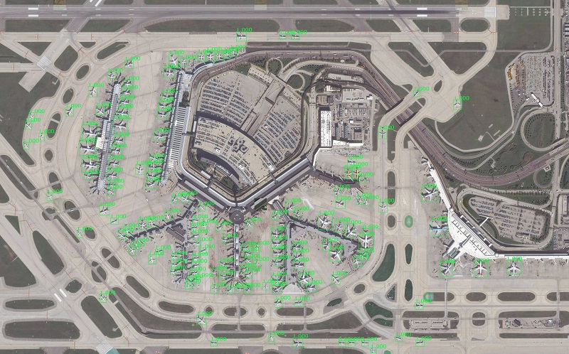
Lockheed Martin has developed a satellite imagery recognition system using open-source deep learning libraries to quickly identify and classify objects or targets in large areas across the world, potentially saving image analysts countless hours manually categorizing and labeling items within an image, the Bethesda, MD-based company announced June 5.
Global Automated Target Recognition runs in the cloud, using Maxar’s Geospatial Big Data platform (GBDX) to access Maxar’s 100 petabyte satellite imagery library and millions of curated data labels across dozens of categories that expedite the training of deep learning algorithms. Fast GPU’s let GATR scan a large area very quickly, while deep learning methods automate object recognition and reduce the need for extensive algorithm training.
GATR teaches itself what the identifying characteristics of an
object area or target, for example, learning how to distinguish between a cargo
plane and a military transport jet. The system scales quickly to scan large
areas, including entire countries. GATR uses deep learning techniques common in
the commercial sector and can identify ships, airplanes, buildings, seaports,
and many other categories.
“There’s more commercial satellite data than ever available
today, and up until now, identifying objects has been a largely manual
process,” said Maria Demaree, vice president and general manager of Lockheed
Martin Space Mission Solutions. “Artificial Intelligence models like GATR keep
analysts in control while letting them focus on higher-level tasks.”
GATR has a high accuracy rate, well over 90% on the models we’ve
tested so far. It only took two hours to search the entire state of
Pennsylvania for fracking sites – that’s 120,000 square kilometers
“I’m not an expert on what oil production sites are, and I don’t
have to be,” said Mark Pritt, senior fellow at Lockheed Martin and principle
investigator for GATR. “This system teaches itself the defining characteristics
of an object, saving valuable time training an algorithm and ultimately letting
an image analyst focus more on their mission.”
GATR builds on research Pritt’s team pioneered during a Intelligence Advanced Research Projects Activity (IARPA) challenge, called the “Functional Map of the World.” The Lockheed Martin team was the only team from a company who placed in the top five.
Source: Lockheed Martin