

From IC Insider Planet
The United States’ mainland body measures about 3,000 miles across. But the U.S. has more than 95,000 miles of shoreline, according to the National Oceanic and Atmospheric Administration. Therefore, to ensure national security and freedom of commerce and navigation, an essential requirement is maritime domain awareness – knowledge of what’s going on in territorial waters.
In fact, the National Strategy for Maritime Security includes a section specifically devoted to maritime domain awareness. It defines the maritime domain as everything “on, under, relating to, adjacent to, or bordering on a sea, ocean, or other navigable waterway, including all maritime-related activities, infrastructure, people, cargo, vessels and other conveyances.”
Silas Ahn defined awareness of the maritime domain in clearer terms: “It’s basically an effective understanding of anything in the global maritime domain that can impact the security, safety, economy and environment of the United States.” Ahn, a former Navy intelligence officer, now maritime analyst at Planet, noted that 80% of international trade occurs on the oceans.
“We also have illicit activities,” Ahn said. “That can range from illicit fishing to smuggling oil, transferring arms to conflict zones, illicit drugs.” Therefore, he said, federal agencies such as the Coast Guard, Navy and Justice, Commerce, Homeland Security and Transportation Departments have an interest in maritime domain awareness. They need to not only see, but also identify and track vessels to stay ahead of potential crime or terrorism.
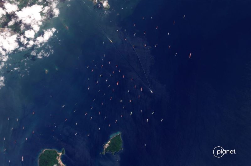
That’s easier said than done. Basic awareness starts with imagery generated by military, civilian federal and commercial satellites and other platforms. Planet, for example, provides federal agencies, among other customers, electro-optical imagery from its fleet of some 200 satellites.
Having even a high-resolution picture of an area and the vessels in it is only a part of domain awareness.
For one thing, ships don’t stay put.
“Once a ship leaves the shore, the coastline, it’s kind of hard to track,” Ahn said, “mainly because the oceans are a big place.” Operators can switch off their automated identification systems (AIS), an internationally used way to identify vessels and where they’re headed. Captains can spoof AIS signals, or hand them off to another ship as a way to evade detection, Ahn said.
Multiple views
No single source of data can give total maritime domain awareness.
“Every source of information has its strengths and weaknesses,” Ahn said. “Our strength is, you can very clearly see what something is without necessarily needing an analyst to tell you, ‘Hey, that’s a cargo ship.’”
But to keep up with where the ship might be headed, analysts must combine optical imagery and signals with other types of data. Ahn said that optical, which depends on daylight and clear skies, is augmented by technologies such as synthetic aperture radar. Other sources add radio signals, radar data and other communications not part of AIS. By clustering multiple data sources, an agency can get a fuller picture of the nature and intentions of a vessel, Ahn said.
He noted that agencies such as the Coast Guard and Navy might be looking for highly specific things, but they need to start with a picture of essentially everything.
“We need to understand the entire picture,” Ahn said. “And for most of history, we haven’t had that capability.” He said Planet images millions of square miles daily. That includes the entire world landmass and selected parts of the oceans, such as the South China Sea.
Views over time form an important element of maritime domain awareness, Ahn said.
“Once you have that macro picture, you can start asking those smaller questions: Hey, where was this ship yesterday? Was it actually transmitting?” Ahn said. Overlaying movement data with AIS transmissions can help analysts understand what’s going on.
Because of the size of the datasets satellites gather, Ahn said, they require sophisticated analytics tools to help human viewers sort out what’s significant. Not only are the waters large, they are also populated with thousands of unevenly disbursed vessels at any given moment.
Should something emerge, Ahn said, “we do have another constellation called SkySat … and because we have enough of those satellites, we can take a picture up to 10 times a day of any specific location.” In the end, the more imagery and other interpreted data reaching the various agencies’ fusion centers, the greater the domain awareness and therefore decision-making confidence.
“The power of fusing that intelligence is that now you can say, ‘OK, I’ve gotten a signal, I’ve got the imagery picture and I’ve got maybe a radar signal,” Ahn said. “And those things all align. Now I have much more confidence that I’ve got a good picture for that single ship.”
On use of commercial imagery in law enforcement and national security, Ahn said, “The beauty of commercial imagery and certainly Planet’s is that it’s 100% unclassified, which makes sharing with our allies and partners much easier.” He added, “There’s no real issue in terms of working with classified information from the perspective of combining it. The question becomes where you do the processing.”
He added, “If there’s a reason to do that processing within classified systems, then we’d work with whatever the user or customer is asking for.”
Learn more about Planet planet.com/markets/maritime/.
Image credit: ©Planet Labs PBC • SkySat • Ship traffic, Panama Canal, Panama • August 3, 2023