


NGA to procure ‘Quick Terrain Modeler’ software support from Applied Imagery
The National Geospatial-Intelligence Agency (NGA) is planning to renew its maintenance contract to support the QT Modeler software it uses to build geospatial models. The firm fixed price award will cover the period from March 1 to August 2, 2014.
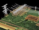
The Quick Terain Modeler (or QT Modeler) software is developed and sold exclusively by Applied Imagery, of Chevy Chase, MD.
“Quick Terrain Modeler is the world’s premier 3D point cloud and terrain visualization software package,” says Applied Imagery about its own software on its own Web site. “Designed for use with LiDAR, but flexible enough to accommodate other 3D data sources, Quick Terrain Modeler provides an easy to use software experience that allows users to work with significantly more data, render larger models, analyze data faster, and export a variety of products. These benefits enable very powerful, yet simple and intuitive, terrain exploitation.”
The NGA indicated in a solicitation it released on Feb. 11 that it is planning to make this procurement as a 100% small business set-aside award.
Further information is available from Patrick Higgins at 314-676-0184 or patrick.j.higgins@nga.mil.


